Switzerland has some of the most scenic hiking trails in the world, from the mountains of the Jungfrau region to the rivers surrounding Geneva, from the Lavaux Vineyard Terraces to the mountains of Ticino, and all points between.
Hiking is one of my favorite pastimes year round, and in this post, I’d like to share with you some of the things I’ve learned about the Swiss hiking system that can help you make the most of your hiking adventures at any level of experience.
In all, Switzerland has approximately 60,000 kilometers of hiking trails, and the trails are consistently and clearly marked nationwide. There are three types of trails in Switzerland: hiking paths, mountain paths, and alpine paths.
Hiking Paths: Also called Wanderweg, Itinéraire pédestre, or Sentiero escursionistico, hiking paths are routes appropriate for most ages and abilities. Paths are usually well-groomed, and steeper areas may have stairs and railings installed. Hiking paths are marked by yellow signs.
Mountain Paths: Mountain paths (Bergweg, Itinéraire de montagne, Sentiero di montagna) are more challenging routes that may follow cliff sides or involve traversing suspension bridges at considerable heights. Hiking shoes and surefootedness are essential. Mountain paths are marked by yellow signs with white and red stripes.
Alpine Paths: Also called Alpinweg, Itinéraire alpin, and Sentiero alpino, alpine paths are the most difficult hiking routes in Switzerland. Alpine equipment is required; light climbing and glacier traverses are common. Only hikers with alpine experience should undertake journeys on these paths. Alpine paths are marked by blue signs.
Route Markers and Guideposts
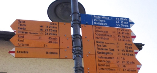
In the photo below, taken in the town of Zermatt, you can see several features of the Swiss hiking system.
- Several destinations are listed, with the estimated time it takes to reach each point from your current location (e.g., it’s a 10 minute hike to Spiss; it’s a 1 hour, 20 minute hike to Täsch).
- Transportation options are also displayed – the train icon next to “Täsch” signifies the Täsch train station is 1 hour, 20 minutes away, and the cable car icon next to “Schwarzsee” shows that it’s a three hour, 40 minute hike to the Schwarzsee cable car station.
- Routes in yellow are walking paths (e.g., Tiefenmatten, Sunnegga, Zmutt).
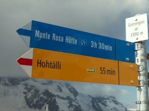
- Mountain routes are indicated by the yellow arrows with white-and-red striped tips (e.g., Arschle, Schwarzsee, Blauherd, Trockener Steg).
- Alpine routes are indicated by the blue arrows (e.g., Rothornhütte, Platthorn, Mettelhorn).
- The snowman symbol next to Ried shows that this trail can be used in winter without any special equipment (however, good shoes are necessary).
- The chalet symbol next to Ottavan, Schönbielhütte, Hörnlihütte, Gandegghütte, and Rothornhütte indicates there is shelter available at that destination.
Directional Trail Markers
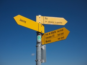
The yellow sign above is a directional trail marker for a hiking route, displayed at road or trail junctions. Signs like this indicate which way the hiking path continues. For mountain trails or alpine trails, the directional markers will be in their respective trail colors (white and red for mountain trails, blue for alpine trails).
Confirmation Trail Markers
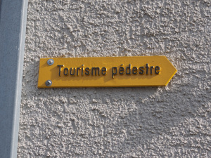
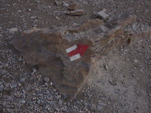
Another type of hiking path sign is shaped like a diamond or a rectangle. These signs may be painted on rocks, walls, or paved paths; posted to trees; or posted on fences or gates. They confirm the route of a designated hiking path – keep an eye out for them to make sure you’re on the right track!
Here are some examples:
Scenic Routes
There are seven national scenic hiking routes in Switzerland: Via Alpina, Trans Swiss Trail, Alpine Panorama Trail, ViaJacobi, Jura Crest Trail, Alpine Passes Trail, and ViaGottardo. These multi-stage routes can be completed in full or in part, and all are designed to offer stunning views of the Swiss countryside. More information about these routes is available by clicking here and selecting “national routes.”
Maps
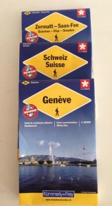 National, regional, and local maps are available for purchase at Swiss Post offices and some book/magazine shops. The maps are published by SuisseMobile and are updated yearly. Typically, maps are waterproof and have text in four languages (German, French, Italian, and English).
In addition to showing national, regional, and/or local hiking routes, the maps contain information such as the locations of campgrounds, panoramic viewpoints, points of interest, castles, ruins, monuments, restaurants, and barbecue sites.
Smartphone Apps
The free Switzerland Mobility app includes national, regional, and local hiking routes using maps published by the Federal Office of Topography (swisstopo), as well as points of interest and public transit stops. Find out more by clicking here.
Swiss Map Mobile is available from the Federal Office of Topography. The app includes topographical maps of the country, plus a tracking function, augmented reality displays, and access to the complete Swiss hiking network. Many features can only be accessed for a fee. Find out more by clicking here.
Mountain Readiness
Suisse Rando publishes a brochure called “Ready For the Mountain?” in English, German, French, and Italian. The organization advocates all hikers follow a checklist using the simple acronym “PACE” when preparing for any hike:
- Plan: In advance, you should research your route, including its duration, terrain, route conditions, and the weather forecast.
- Assess: You are the best person to assess whether or not you are prepared for the route you plan to undertake. Take into account your hiking experience, abilities, and the demands of the route (e.g., mountain routes versus easier paths) and plan to hike a route suitable to your level of fitness, experience, and surefootedness.
- Consider: Consider what you need to bring along on the hike. Be sure to wear appropriate shoes and clothing (e.g., dress in layers, as weather may change unexpectedly). In a backpack or daypack, consider taking with you a map, cell phone, GPS device, water, snacks, first-aid materials, and lightweight blanket.
- Evaluate: Along the route, monitor yourself. Is the hike more demanding than you expected? Rest as often as you need. Monitor weather changes, the time of day, and your hunger and thirst. Stay on the marked paths.
More resources related to Swiss hiking trails:
- Wandern.ch, homepage of SuisseRando, the national organization of Cantonal hiking trail organizations and associations
- SwitzerlandMobility, a site for hiking, biking, mountain biking, and inline skating trails across the country
- Swiss Alpine Club
We are a group of international women living in Geneva, Switzerland. If you would like to join the AIWC, please visit our website at http://www.aiwcgeneva.org/.



Can I sleep in a tent along any of these trails? Are there any concerns (permits, safety, not/authorized areas)?
michels, I’m sorry about my late reply! I have been traveling and left my phone. It’s been a week without access. Officially you are not allowed to camp “wild” in Switzerland. Quite honestly, I think it comes down to Switzerland is a small country with a lot of visitors. They would like to keep the trails tidy, the views undisturbed and the human waste to a minimum. Hikers can stay at refuges, hotels and farms that provide lodging even in some of the highest mountain areas.
Hi
Which hiking would you recommend near Nyon to do during a day in early December? Level easy or medium.
Thank you!
Merce
Hello! I’m sorry I didnt respond sooner. I didnt receive a notification of your question! I personally don’t hike in the canton of Vaud very often but I have done portions of the Toblerone trail which I note in the blog What to do with Summer Guests outside Geneva along our lake. Another great tool to use is the website and app to Switzerland Mobility.